The Top 3 Osoyoos Hiking Trails
Walk the landscape of BC’s only desert. Here are our top 3 Osoyoos hiking trails that will get your legs moving and reward you with magnificent views of Osoyoos Lake.
There are plenty of great walking trails in and around Osoyoos, whether you’re looking for a quiet stroll after dinner, or a more challenging hike to get your heart pumping. To help you experience the most beautiful views this southern Okanagan Valley town has on offer, we have made a list of our top 3 Osoyoos hiking trails.
1. Irrigation Canal Walkway
LEVEL: EASY WALK – 5KM LOOP
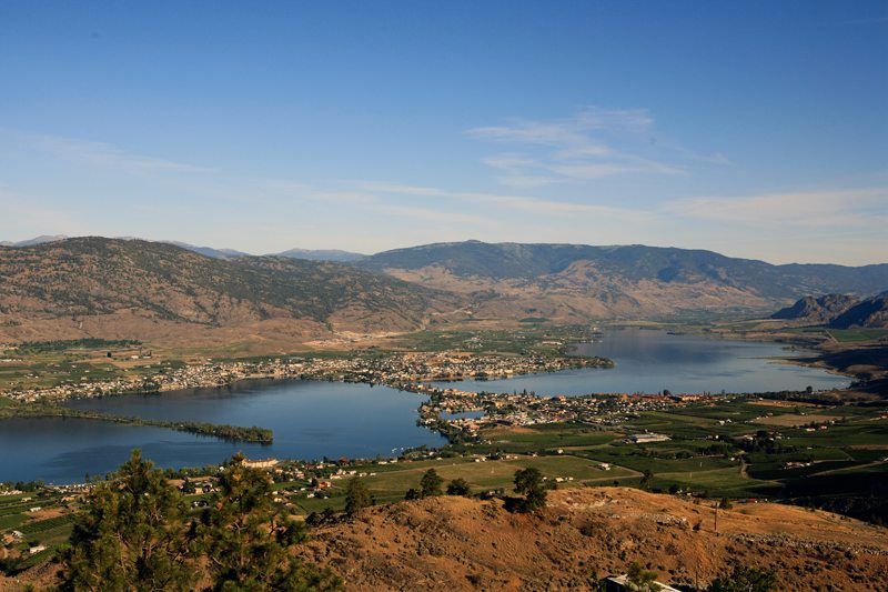
The Irrigation Canal Walkway is a 5km loop that is popular for biking, horseback riding and walking.
The trail follows an old irrigation canal, which was built in 1920 and used to irrigate the local wineries and orchards. During the town’s initial years of development, this irrigation system was the sole water source for Osoyoos. This walk is really great for getting a glimpse of the unique desert plants that are native to this region of the Okanagan Valley. Enjoy beautiful views of sage-dotted mountains as well as orchards and vineyards in the valley. The trail also offers great views of Osoyoos Lake.
Details
- Easy walk
- Trail Length: 5 km loop
- Surface Type: Unpaved
Location
Travel south on Highway 97 and turn right on 62nd Ave. Pass the Elks Hall and proceed up the hill to a local secondary school. Just north of the school is a parking lot near the trailhead. The trailhead is marked by an information sign.
2. Mount Kobau
LEVEL: EASY HIKE – 4-KM LOOP
Take in the spectacular 360 degree views from the summit of Mount Kobau, one of the tallest peaks in the area (1,873 m / 6,145 ft).
From the top you can see the expanse of the Okanagan Valley (including Osoyoos and Cawston), the Similkameen Valley and the Cascade Mountains. From the parking lot at the summit of Mount Kobau, there is a 1km walking trail. This short trail is steep in some parts. This is also where you will find the trailhead for Testalinden Trail, which is a 4km loop. This is an easy and flat trail that passes through alpine meadows with wild flowers and offers breathtaking panoramic views of the sensational surrounding area. This gratifying hike makes you feel like you’re on top of the world! Please note that after adverse weather conditions, fallen trees/logs may obstruct this trail.
Mount Kobau is a popular spot for stargazing and a group of local volunteers host an annual Star Party over the August Long weekend. This is a great, informal, family-friendly event for any budding astronomers to come and enjoy great views of the constellations with some keen interpreters willing to share their knowledge of the night sky.
Details
- Trail length: The trail to the summit of Mount Kobau is 1km. The Testalinden Trail is a 4km loop
- This trail is located within a provincial park. Please stay on designated trails. Mushroom picking (as well as flower picking) is prohibited within all provincial parks
Location
From Osoyoos, take Highway 3 to Cawston (about 11km) and turn right on Kobau Mountain Forest Service Road. (Look for a BC Government sign for Spotted Lake.) This road is 20 km and will lead you to the top of Kobau Mountain.
3. McIntyre Bluff
LEVEL: INTERMEDIATE HIKE – 10KM ROUND TRIP
This hike is just outside of Osoyoos, in Oliver, BC, at about a 30 minute car ride away. However, for those with vehicles it is well worth the trip. The 10km round trip is a gradual uphill trek, with a few fairly steep moments. Once you get to the top it provides stunning views of the Okanagan Valley. In fact, it’s such an iconic sight that it is often the image featured on postcards of the area! Enjoy views of orchards, vineyards, and Gallagher Lake.
The best time of year to do the McIntyre Bluff hike is in late spring or early summer when the wildflowers are in full bloom. Be mindful of the fact that the Okanagan gets quite hot and dry in the summer months, and there is very little shade on the hike up. Brings lots of water and do it at a pace that is most comfortable to you and your group. Additionally, many choose to bike this trail as well! On bike, the trail takes about 90 minutes, while hikers tend to finish the trail in 2-3 hours.
Note that the trailhead to the McIntyre Bluff hike is located at Covert Organic Farms Wine Lounge. Hikers can choose to stop at the Wine Lounge for a refreshing glass of Okanagan Valley wine after a fun day of exercise.
Details
- Trail length: 10km round trip
- The trail can be done by foot, bike or horseback
- This hike is located just 30 minutes outside of Osoyoos
Location
Take Highway 97 north, up towards Oliver. Take the Secrest Hill Road turnoff and follow it for 1.5km before turning right onto Covert Place. Continue on the main road, and follow it up until the top of the hill. At the top you will come across Covert Organic Farms on your right. Follow the gravel driveway, and there will be a parking lot on your left. Once parked, follow the signs for “Bluff Hike” and “Wine Lounge”, where the trailhead is located at the Wine Lounge.
Planning an Osoyoos Getaway?
If you’re looking to wander the vineyards and look over Osoyoos lake, we have a fantastic array of vacation rentals. Check out our list of excellent Osoyoos accommodations here or give our Destination Experts a call on 1.877.902.1616 – we’re available 7 days a week and can easily assist you with finding the perfect property.
- 506 - 1168 Hamilton St Vancouver, British Columbia Canada, V6B 2S2
- +1 877 902 1616
- [email protected]
- Carrer Isaac Newton 2 Bloc A, d l'Edifici Naorte, Oficina 9 Parc Bit Palma de Mallorca, Islas Baleares Spain, 07121
- +34 871 550 584
- [email protected]
